Out: 11/12 19:00
Due: 11/26 19:00
Collaboration:
Collaboration on solving the assignment is allowed, after you have thought about the problem sets on your own. It is also OK to get clarification (but not solutions) from online resources, again after you have thought about the problem sets on your own.
There are two requirements about collaboration:
Cite your collaborators fully and completely (e.g., “XXX explained to me what is asked in problem set 3”). Or cite online resources (e.g., “I got inspired by reading XXX”) that helped you.
Write your scripts and report independently - the scripts and report must come from you only.
Submitting your assignment:
Please write a report PS3.pdf.
Create a jupyter notebook named PS3.ipynb.
Upload your jupyter notebook and report to your
Github ESE5023_Assignments_XXX repository (where
XXX is your SUSTech ID) before the due time.
Late Submission:
Late submissions will not receive any credit. The submission time will be determined based on your latest GitHub file records.
Methane (CH4) is a naturally occurring Greenhouse Gas (GHG), but one whose abundance has been increased substantially above its pre-industrial value by human activities, primarily because of agricultural emissions (e.g., rice production, ruminants) and fossil fuel production and use. A clear annual cycle is largely due to seasonal wetland emissions.
Atmospheric methane abundance is indirectly observed by various satellite instruments. These instruments measure spectrally resolved near-infrared and infrared radiation reflected or emitted by the Earth and its atmosphere. In the measured signal, molecular absorption signatures from methane and constituent gasses can be identified. It is through analysis of those absorption lines in these radiance observations that the averaged methane abundance in the sampled atmospheric column can be determined.
For this problem set, methane levels have been determined by applying
several algorithms to different satellite instruments. Download the
netCDF4 file
(200301_202006-C3S-L3_GHG-PRODUCTS-OBS4MIPS-MERGED-v4.3.nc),
which contains monthly-averaged methane levels (xch4) in
the unit of ppb at each 5° (lon) x 5°
(lat) grid over the globe from 2003-01 to
2020-06.
1.1 [5 points] Compute methane climatology for each
month, and plot your results in 12 panels.
1.2 [5 points] Plot globally-averaged methane from
2003-01 to 2020-06 as a time series. Describe
your results. Check your plot with this one.
1.3 [5 points] Plot deseasonalized methane levels at
point [15°S, 150°W] from 2003-01 to
2020-06 as a time series. Describe your results.
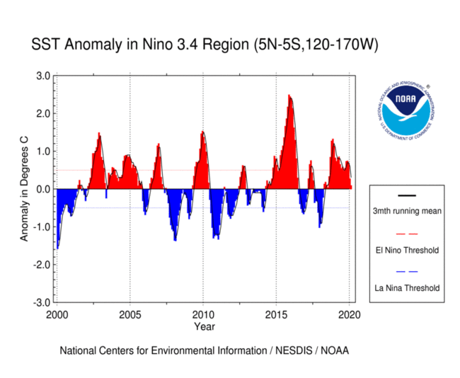
The Niño 3.4 anomalies may be thought of as representing the
average equatorial sea surface temperatures (SSTs) across the Pacific
from about the dateline to the South American coast (5N-5S,
170W-120W). The Niño 3.4 index typically uses a 3-month
running mean, and El Niño or La Niña events are defined when the Niño
3.4 SSTs exceed +/- 0.5°C for a period of 5
months or more. Check Equatorial
Pacific Sea Surface Temperatures for more about the Niño 3.4
index.
In this problem set, you will use the sea surface temperature (SST)
data from NOAA. Download the
netCDF4 file (NOAA_NCDC_ERSST_v3b_SST.nc).
1.1 [10 points] Compute monthly climatology for SST from Niño 3.4 region, and subtract climatology from SST time series to obtain anomalies.
1.2 [10 points] Visualize the computed Niño 3.4. Your plot should look similar to this one.
netCDF datasetBrowse the NASA’s Goddard Earth Sciences Data and Information
Services Center (GES DISC) website. Search and download a
dataset you are interested in. You are also welcome to use data from
your group in this problem set. But the dataset should be in
netCDF format, and have temporal information.
3.1 [5 points] Plot a time series of a certain variable with monthly seasonal cycle removed.
3.2 [10 points] Make at least 5
different plots using the dataset.