Assignment 04
Out: 11/26 19:00
Due: 12/10 19:00
Instructions
Collaboration:
Collaboration on solving the assignment is allowed, after you have thought about the problem sets on your own. It is also OK to get clarification (but not solutions) from online resources, again after you have thought about the problem sets on your own.
There are two requirements about collaboration:
Cite your collaborators fully and completely (e.g., “XXX explained to me what is asked in problem set 3”). Or cite online resources (e.g., “I got inspired by reading XXX”) that helped you.
Write your scripts and report independently - the scripts and report must come from you only.
Submitting your assignment:
Please write a report
PS4.pdf.Create a jupyter notebook named
PS4.ipynb.Upload your jupyter notebook and report to your Github
ESE5023_Assignments_XXXrepository (whereXXXis your SUSTech ID) before the due time.
Late Submission:
Late submissions will not receive any credit. The submission time will be determined based on your latest GitHub file records.
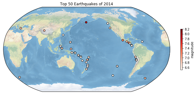
1. Global Earthquakes
In this problem set, we will use this
file from the USGS Earthquakes Database. The dataset is similar to
the one you use in Assignment
02. Use the file provided (usgs_earthquakes.csv) to
recreate the following map. Use the mag column for
magnitude. [10 points]
2. Explore a netCDF dataset
Browse the NASA’s Goddard Earth Sciences Data and Information
Services Center (GES DISC) website. Search and download a
dataset you are interested in. You are also welcome to use data from
your group in this problem set. But the dataset should be in
netCDF format. For this problem set, you are welcome to use
the same dataset you used in Assignment
03.
2.1 [10 points] Make a global map of a certain variable. Your figure should contain: a project, x label and ticks, y label and ticks, title, gridlines, legend, colorbar, masks or features, annotations, and text box (1 point each).
2.2 [10 points] Make a regional map of the same variable. Your figure should contain: a different project, x label and ticks, y label and ticks, title, gridlines, legend, colorbar, masks or features, annotations, and text box (1 point each).